7/9/96 - T+8 - Picket's Charge
Today's update will basically be a guided tour of Gettysburg PA and it's main feature,
the Battleground. My primary focus for the day was the area of the third day's battle,
Picket's Charge. No student of military operations cannot look at Picket's Charge and not
get lump in their throat and have a sense of respect for those brave young men.
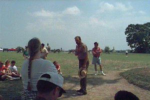 The day started of with a guided tour of
the High Water Mark given by Ranger Tom Holbrook. I met Tom yesterday at the Easter
Cavalry Fields. He's a true student of history and loves his job of showing all of us this
bit of American history.
The day started of with a guided tour of
the High Water Mark given by Ranger Tom Holbrook. I met Tom yesterday at the Easter
Cavalry Fields. He's a true student of history and loves his job of showing all of us this
bit of American history.
For those of you who are not aware, Picket's Charge was the grand frontal assault lead
by General George Picket on July 3, 1963. This battle was the deciding moment of the
battle at Gettysburg. 12,000 Confederate infantry men lined up in rank and file and
charged over 1 mile of open and broken ground into 8,000 dug in Union troops with heavy
artillery support. Over half of the 12,000 men that left the safety of Seminary Ridge were
killed outright, another 2,500 were wounded. By all, this is considered the last great
frontal charge made by American troops.
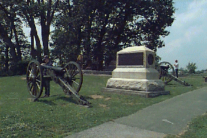 This first image is of the monument to
Cowan's 1st New York Battery, 6th Corps, who were stationed on top of Cemetery Ridge. This
is the unit that received that now infamous order of "Double canister at 10
paces." This effectively turned the 200 yards in front of the guns into a human meat
grinder.
This first image is of the monument to
Cowan's 1st New York Battery, 6th Corps, who were stationed on top of Cemetery Ridge. This
is the unit that received that now infamous order of "Double canister at 10
paces." This effectively turned the 200 yards in front of the guns into a human meat
grinder.
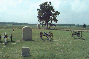 This picture was taken while standing on
one of the gun caissons belonging to Cushings Battery which was captured for a short time
by Confederate troops at the apex of the attack. This point has become known as the
"High Water Mark" of the confederacy. In the picture you can see the low stone
wall in the background which takes a 90 degree turn and forms what survivors of the battle
refer to as "The Angle". The Angle is where Confederate troops breached the
Union line and the fighting was hand to hand until the Confederates were finally repelled.
This ground could be describe as nothing other than a killing field. It's 130 years later
and you can still feel the bad karma in this area!
This picture was taken while standing on
one of the gun caissons belonging to Cushings Battery which was captured for a short time
by Confederate troops at the apex of the attack. This point has become known as the
"High Water Mark" of the confederacy. In the picture you can see the low stone
wall in the background which takes a 90 degree turn and forms what survivors of the battle
refer to as "The Angle". The Angle is where Confederate troops breached the
Union line and the fighting was hand to hand until the Confederates were finally repelled.
This ground could be describe as nothing other than a killing field. It's 130 years later
and you can still feel the bad karma in this area!
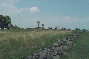 Along the right
side of this picture you can see part of the stone wall after the angle. The 26th Regiment
from North Carolina charged up this channel into a weathering field of cannon and musket
fire. Of the whole regiment, only 3 men reached the Union lines alive. The entrenched
Union troops had so much respect for these 3 men that they ceased fire and an officer
stepped on top of the wall and extended his hand to them and invited the to "Come on
over to God's side." In the middle of the picture you can see a small marker placed
by the people of North Carolina to honor the bravery of these men. On that marker is
inscribed "The men of the 26th Regiment would dress on their colors in spite of the
world." This if anything sums up the dedication and honor of the south!
Along the right
side of this picture you can see part of the stone wall after the angle. The 26th Regiment
from North Carolina charged up this channel into a weathering field of cannon and musket
fire. Of the whole regiment, only 3 men reached the Union lines alive. The entrenched
Union troops had so much respect for these 3 men that they ceased fire and an officer
stepped on top of the wall and extended his hand to them and invited the to "Come on
over to God's side." In the middle of the picture you can see a small marker placed
by the people of North Carolina to honor the bravery of these men. On that marker is
inscribed "The men of the 26th Regiment would dress on their colors in spite of the
world." This if anything sums up the dedication and honor of the south!
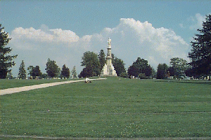 Our next stop
is the National Cemetery at Gettysburg. This cemetery is the final resting place of 3,500
of the approximately 12,000 fallen Union solders killed at Gettysburg in the three bloody
days of fighting. This is the local where President Lincoln gave his famous Gettysburg
Address. The graves are in a semicircle around the monument that you see in the middle. I
took this picture while standing in the Pennsylvania section. All of the men buried here
are placed in sections for each state of the Union army. The Confederate dead are not
buried here, they were moved from the Gettysburg area to the Hollywood Cemetery in
Richmond VA after the war. Because this is a national cemetery, there are also soldiers
here from other wars, including many Medal of Honor winners.
Our next stop
is the National Cemetery at Gettysburg. This cemetery is the final resting place of 3,500
of the approximately 12,000 fallen Union solders killed at Gettysburg in the three bloody
days of fighting. This is the local where President Lincoln gave his famous Gettysburg
Address. The graves are in a semicircle around the monument that you see in the middle. I
took this picture while standing in the Pennsylvania section. All of the men buried here
are placed in sections for each state of the Union army. The Confederate dead are not
buried here, they were moved from the Gettysburg area to the Hollywood Cemetery in
Richmond VA after the war. Because this is a national cemetery, there are also soldiers
here from other wars, including many Medal of Honor winners.
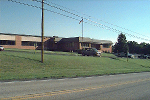 On to cheerier subject, another point of
interest in Gettysburg is the FCC division that handles licensing for ham radio operators.
On to cheerier subject, another point of
interest in Gettysburg is the FCC division that handles licensing for ham radio operators.
After my tours of Gettysburg, it was back to the road. I headed south and dropped below
the Mason Dixon Line. For those of you who don't know, the Mason Dixon Line is basically
the horizontal line formed by the lower boundary of Pennsylvania. the Mason Dixon line
dates back to the 18th century and was used in forming the boundary of today's
Pennsylvania.
I continued south through Maryland and West Virginia, and on into Virginia. I'm
officially in the south now. I'm bedded down in a small town called Luray VA. I had not
planned on this section of trip, but there are some can't miss sites recommended by my
friend Paul Fetcher. You'll be hearing more about them tomorrow.
Sleep tight and take care!